 |
||
08/22/08 |
|
|
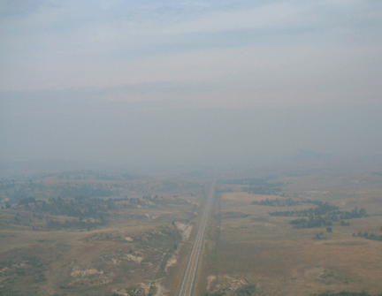
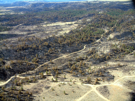
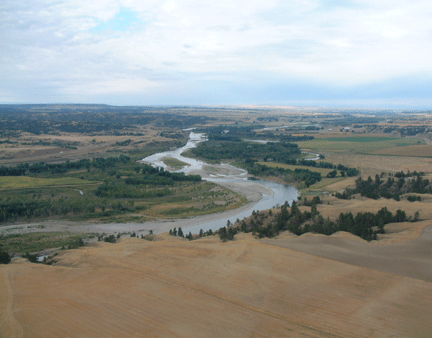
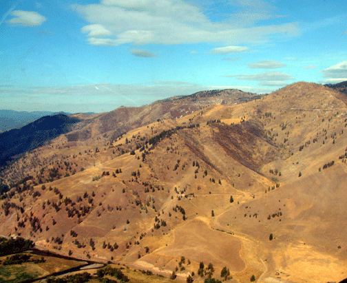
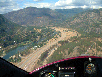
September 10, 2005 I drive the courtesy van back to the airport and quickly get the gyro ready for flight. The wind is already up over 15 knots even though it's only 7:15 in the morning. I'm expecting to fly through some light rain somewhere between here and our destination at Billings where I will rejoin Dee. My climb out here is not too bad as the field elevation is only 2,958 and the morning air is still cool. However once I have climbed up a few hundred feet and headed on my way I see my speed over the ground is a paltry 40 knots due to the building westerly winds. Some days flying is like being as free as a bird and I swoop and dive at will and other days it is like a chess game with constantly changing conditions. Today it's chess again. My first planned stop is Miles City 103 miles away and at this speed I am in danger of running out of fuel before I can get there, so before I have gone a dozen miles I am already recalculating my options. Baker, Montana is only a slight detour so I check my book to see if they sell fuel there--yes so that's OK. But wait there is another problem- the winds are 20+ knots from slightly south of west and the runway at Baker runs NW to SE which will be a problem. In my gyro I can usually find a way to land into the wind on a short taxiway or part of the parking ramp, but for takeoff I'll need to use the regular runway. I snap a few early morning pictures on my way to Baker then fly over the runway looking for the best spot to land. The short taxiway is more aligned with the wind than the runway so that would be preferable but then I see the parking ramp is deserted and I come in low and jog around a hanger then face into the wind and set down gently on the ramp. No one is about as I refuel then taxi back out. In strong cross winds I've found my best bet is to make sure to hold the gyro onto the ground until I have plenty of airspeed so once I break ground I can climb quickly away from the runway but I know I'll have my hands full here. The wind is 20 knots and is 60 degrees off of the runway angle. My rotors come up to speed quickly in the strong winds but I need an extended take-off roll to get enough speed. When my speed hits 70 knots I let the gyro lift off the ground then I turn it into the wind so I am crabbing sideways but still flying over the runway which is the normal procedure. Unfortunately the gyro climbs about 10 feet then starts to settle back towards the runway. If I were to touch down now with the gyro going sideways it would roll over for sure. I am just able to keep it above the runway and milk the airspeed up until she is flying. Even after the immediate danger is over I'm still only climbing at about 200' per minute. This is one of the scariest take-offs I've ever had. Belatedly I realize that I would have been better to fly directly into the wind immediately after take-off. If I settled back to the ground it would have been in the dirt and weeds off of the side of the runway but at least I would have been going straight ahead and not risked rolling over. Whew, what a close call. I fly on over very remote and deserted countryside for a few dozen miles then see what looks like a fog bank ahead. I think it must be rain but as I near I see it is a wall of haze caused by a forest fire to the North. As soon as I am in it the visibility drops to under 2 miles and I taste the smoke in my mouth. I fly along like this for another dozen miles seeing very little. The ranches are few and far between in these parts so as I pass them I mark them on my GPS. If I had to land in the middle of nowhere help might be 10 miles away but at least I would know which way to walk. After flying in the smoke and reduced visibility for 15 minutes I decide to detour a few miles away to where a road parallels my route. Seeing the road and cars below provides some comfort and makes me feel less remote. Eventually the smoke thins out and shortly after I cross the Powder River I'm in clear air again. Miles City is up ahead and it is going to be a repeat of Baker with no runway facing into the wind. Again though I find a taxiway facing directly west so I set down on that just as two fire fighting tanker planes take-off to dump slurry on the fire North of us. My call to flight service informs me of rain all along my route to Billings so when Dee and I speak we agree to meet later this afternoon in Hysham, Montana a little tiny whistle stop of a town that happens to have a small gravel runway nearby. The pretty lady running the airport helps me roll my gyro in out of the rain then gives me the keys to the airport car and directions to a local restaurant for lunch. Later while waiting out the rain she tells me all about small town living in eastern Montana. By midafternoon the rain has moved on so I launch westwards over the Montana prairie. I see the small little used runway at Hysham and decide I better fly over it and check its condition. I'm surprised to see it has been recently paved and Dee is below waving to me with both arms raised overhead. I land easily and taxi the gyro right up next to the motorhome. There are only 2 airplanes based here and they are stored in open sided sheds, while our closest neighbors for the night are the cattle grazing just over the fence from where the motorhome and gyro are parked. When we go for a sunset walk down the runway we can just barely see lights twinkling in the town a few miles away.
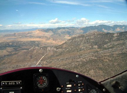
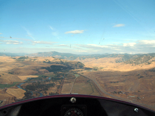
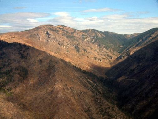
September 11, 2005 There is more rain expected today but we are determined to get to Bozeman where we plan to rendezvous with friends from Colorado who are up here on a fly fishing trip. I depart Hysham waving to Dee as I go overhead and then I fly along the beautiful valley of the Yellowstone River. Up ahead is the first of two high passes I must get over so I am a bit concerned and the scattered rain showers ahead don't provide much comfort. In addition I find several factors conspiring against me. Since there is less oxygen at higher altitude airplane engines have a fuel mixture control so you can send less fuel to the engine as you climb. This keeps the fuel and oxygen ratio the same as at sea level. Cars do this automatically with fuel injection. However my gyro engine is carbureted and I have no fuel control so the engine is getting much more fuel than it needs or can use. In addition since I am at high altitude and the engine needs more horsepower I have been running at nearly full throttle just to keep airborne. As if these two factors were not enough the west wind blowing against me has often slowed me to 35 knots over the ground. Normally I can plan 120 miles between fuel stops and still have plenty of reserve but now I must plan on refueling every 80 miles. I make brief fuel stops at the airports in Laurel Montana outside Billings and again at Livingston. Jimmy Buffett is my favorite singer and his song "Livingston Saturday Night" is running through my head as I take-off and begin climbing up to Bozeman Pass at 6,002 feet. I want to go over the pass with at least 800 feet clearance and more if I can manage it. As I near the pass I go through several light rain showers which add more drama to the climb for me, but soon I am over 7,500 feet and can comfortably enjoy the scenery around me. Since I normally fly only a few hundred feet in the air this perspective of several thousand feet above the terrain is a definite change of pace. As soon as I pop through the pass I see the town of Bozeman laid out below me. This is a towered airport so I call in and report my position. Small aircraft are normally told to approach from the side and then line up with the runway when about 1 mile from the runway end but today the tower operator treats me like a big jet and tells me to make a straight in approach from about 7 miles away. A jet going 3 or 4 miles a minute would only spend a minute or two on the approach and I am sure she has no idea that it will take me nearly 10 minutes to get to the airport. Nevertheless it is not crowded today so I just keep flying down the approach and finally touchdown using up about 20 feet of the 9,000 foot long runway.
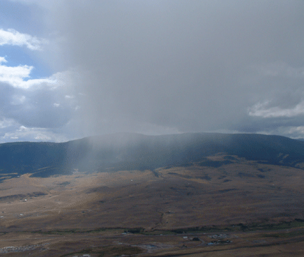
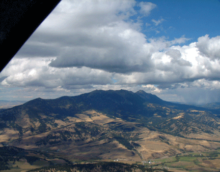
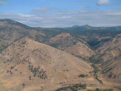
September 12, 2005 When we awaken this morning it is 39 degrees and overcast. The sky looks menacing but flight service reports the clouds are 7,000 above ground so at least we can get over the nearby mountains even if the rain to our north prevents us from getting all the way to Missoula, our planned destination. So far on the trip I have never used the doors on the gyro but today I finally breakdown and put the doors on for warmth. The doors should also streamline the gyro making it fly faster in this high altitude and the cold air will also help. Aircraft are affected by something called density altitude. This is the effect of the temperature on the air density. A runway at 4,500 feet elevation is said to be normal density altitude when the temperature is 45 degrees. But if the temperature goes up to 96 degrees like I had just 2 days ago in North Dakota that same runway would be the equivalent of a runway at 7,700 feet, however today with the temperature at 39 degrees the aircraft will fly better because it will think it is at only 4,100 feet. We have a host of friends to see us off from the Bozeman airport so I make my climb out right over their heads so they can take pictures. With a 9,000 foot runway I have room to spare. Because of my high fuel consumption I decide to stop at an airport 30 miles away and fill up so I will have plenty to get me over the mountains and down to lower terrain. On the way I will pass Butte, Montana but since it is at 5,500 feet I would rather not have to land and take-off again from such a high altitude airport. After so many hours flying with the wind and engine noise today's flight with the doors on is positively civilized. I feel as if I should be sipping tea with my pinkie raised. The gyro flies better this way and I'm warm and toasty in just a light sweatshirt. I land on the grass runway at Three Forks and taxi up for fuel. The fuel operator gives me some advice about the route ahead over the Continental Divide and a few minutes later I'm off. There is more bad weather near Missoula but at least the next section looks OK. I start climbing immediately after leaving Three Forks and am soon at over 6,500 feet. The terrain is rugged and the mountains on both sides are very dramatic as they begin to close in on me as I get closer to the Continental Divide. At one point I fly over some greenery below and experience sinking air and quickly loose 300 feet even though I am at full power. I go into a shallow bank to get over the brown baked earth of a shallow hill and there I find a rising column of air that I ride up to 7,200 feet where I feel more secure. I take several pictures then the camera tells me the memory card is full. I'm momentarily disappointed but then realize that NOT taking pictures will be perfectly fine. After 30 years as a documentary cameraman I actually relish the fact that I cannot take pictures and am free to just experience the moment. Unbeknownst to me Dee is on the highway directly below me. It is one of only 2 or 3 times we have actually seen each other underway and now she spots me just as we both near the top of the North American continent. With no wind against me I am going about 60 miles an hour and Dee in the motorhome is laboring up the hill at a slower speed so she sees me fly on ahead of her while she pumps her fist in the air and cheers us both on. Moments later we come into the dramatic valley where Butte, Montana sits and we transit on past it to cross the high plains towards Anaconda and our meeting spot at Deer Lodge. To my left a solid wall of clouds are moving in my direction and half an hour after I've landed the calm has been replaced by cold gusty winds and the beginnings of a rainstorm. Flight Service confirms that we are in for a day and a half of bad weather so we abandon our plans of Missoula and instead look forward to exploring tiny Deer Lodge. The airport here is too small to have anyone running it full time but I call Ron Kelly the Deer Lodge bank President and a local pilot who immediately comes out to the airport and offers me space inside his hangar as long as we are here.
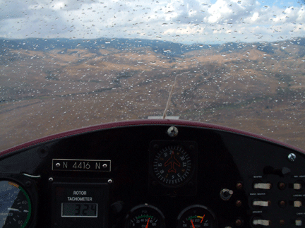
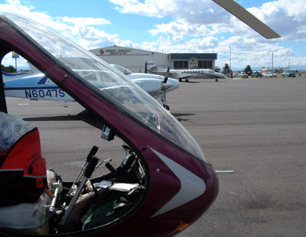
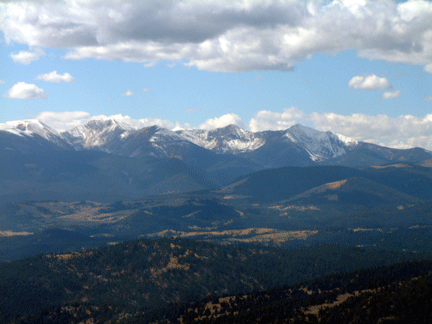
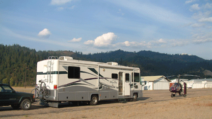
September 14, 2005 Our day and a half in Deer Lodge has been thoroughly enjoyable and we are refreshed and ready to move on. The morning dawns with heavy low clouds but unlike yesterday today there is space between the tops of the mountains and the bottoms of the clouds so I should be able to fly over the passes and get to lower terrain in Idaho. As I ready to depart Ron comes out to see us off and provides a bit of local advice about the route ahead. At his suggestion I decide not to fly over the rough mountains to Thompson's Falls for fuel and instead to meet Dee at a small airport where I can land but which does not sell fuel. It is an extra burden on Dee but she readily agrees if it will make my flight safer and easier. Flying over the Midwest it is easy to point the aircraft in any direction and go where you want but here in the mountains local advice about which valleys to follow and where to fly is invaluable. The first leg of the flight to Missoula is downhill and easy going with calm winds. It is cold outside but I am warm and toasty here with the doors on the gyro. When I get in sight of the Missoula airport I call the tower and request landing permission. At first they do not hear me but as I get closer my radio reception improves and I'm cleared in to land. In no time I'm down and taxiing over to one of the two FBO's here. The FBO heard "gyrocopter" and thought "helicopter" and so when I arrived there was a large group of soldiers watching me taxi up. It seems they were inside waiting for a Blackhawk helicopter and the FBO operator thought I was their ride. Maybe they thought the machine shrunk in the spin cycle. After a quick lunch in the terminal restaurant I'm airborne again to meet Dee for fuel at Mineral County airport. This airport had been closed to civilian traffic for much of the late summer because it was being used as a fire fighting base to battle several nearby forest fires, but now it is open again so I swoop in to check the windsock and wave to Dee down below, then slam the gyro into a tight turn and come in for what turns into a bouncy landing. As I fuel up Dee chats with the only other person at the airport. She tells me inside his hangar he was building a plane that looked like a miniature stealth bomber. I spend a few minutes putting some super glue on a tiny crack that has developed in my fiberglass rudder, then taxi out and fly away. From here I have a very long climb up to the next high pass. The gyro does not want to climb and for 15 minutes I am at full power and barely going up at all. Then what has been a calm day suddenly turns very windy and the gyro bucks and heaves in the very strong gusts. The doors provide warmth but they also make the gyro more susceptible to gusty winds. I am flying up a narrow canyon and on both sides of me the mountains tower several thousands of feet overhead. For about 10 miles the winds push me around then gradually subside and the gyro becomes more stable. I'm still having trouble climbing so I decide that instead of flying up the middle of the canyon I will fly close to the canyon walls and see if I can get some lift from rising air currents. This is a little scary but it works immediately and up I go. Eventually I get so much updraft that I climb far higher than I need and end up reducing power and moving the stick forward to descend. I cross the pass easily at 6,800' and now have a long descent to the airport in Idaho that is at only 2,200'. No sooner have I landed than the airport manager and his son come out to see the gyro and a minute later Dee pulls up in the motorhome. We park the gyro and motorhome side by side on the empty ramp then pull out the BBQ and enjoy the scenery.
|
|
Home | Log 1- Arizona, New Mexico, Texas | Log -2 Louisiana | Log 3- Florida | Emergency Landing | Log 5- Georgia, So. Carolina | Log 6- North Carolina | Log-7 TN, KY, WVA | Log- 8 Virginia | Log-9 MD,PA,DE, NJ | Log 10- New York | Log 11 CN, RI, MA | Log 12 NH, ME, VT | Log 13- NY, OH, MI | Log 14- Indiana | Log 15- IL, WI, MN | Log 16- IA, KS, NE | Log 17- CO, WY & Dakotas | Log 18- Montana | Log 19- Idaho,Wash, Oregon | Log 20- California | Log 21- Nevada, Utah
This site was last updated 10/16/05